ESC -
Croatia - Dinara
, 1830m - Info | VR TourIntroduction:
Shortly after the independents of Croatia from Yugoslavia, Veliki Troglav at 1913m, appeared in list as Croatia's highest point. This is in fact an error. Troglav in fact lies half a kilometre over the countries boarder in neighbouring Bosnia.
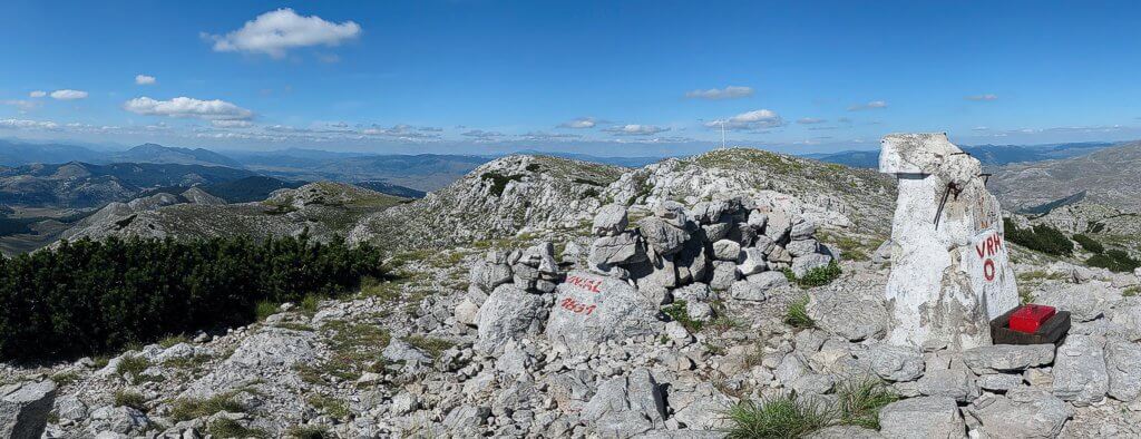
Croatia's true high point, Dinara (aka Sinjal), is located on the limestone ridge of the Dinaric Alps, set 16Km back from the sea, near the city of Knin in Šibnik an Knin County, Dalmatia. The southern face of the ridge is steep, barren and craggy, whilst the northern side slopes more gently into the hinterland and Bosnia.
Extremely hot dry during the summer, temperatures in Knin frequently top 40 °C plus. In such heat the views become hazy. In the winter there will be heavy snow on the mountain which can last well into late spring. The Bura, a strong northerly wind, can blow walkers off their feet in early spring and early autumn.
This is karst country, the limestone extremely porous and you need to carry every drop of water that you'll need. The water that does fall swiftly finds it's way underground into naturally reservoirs that eject whole rivers into the valleys. The most famous of these is the Krka, which flows out into the sea at Šibnik. This most spectacular river and it's environs lie protected in the Krka National Park. A day here spent exploring the travertine waterfalls is one well spent.

|
| Dinara's summit. |
Routes :
Warning : Knin was a Serb strong hold during the Yugoslavian conflict of the 1990s, and very heavy fighting took place here towards the war's end in 1995. Much of the region remains off limits due to the extensive use of landmines.
In August 2005, the Hrvatski Planinarski Savez (Croatian Mountaineering Association) gave me the following advice:
|
Please wait for Google Map to load here.
|
| GoogleMaps |
Getting there and away :
-
By Air - British Airways and other European flag carriers fly direct to
Zagreb Airport
(Croatia's capital city), and the closer
Split Airport
. For those with more time to travel and less money to spare, the budget airlines fly to Trieste in Italy and Klagenfurt in Austria. You'll then need to travel by rail, bus or car to Knin (the closest town to Dinara), or Šibnik if staying for a longer period.
-
By Road - In the summer of 2005 the new Zagreb / Split highway opened cutting down the time to reach this once distant region. There is a toll charged for use of this highway.
For those relying on public transport, check out coach times from the coach stations in Zagreb, Split, and the country's second city Rijeka.
- By Rail - Zagreb, Split, Knin and Šibnik are all on the Croatian rail network run by Hrvatske Zeljeznice.
Accommodation :
Hotels & Hostels. Knin is the nearest town of significant size to Dinara. In fact it is possible to make an ascent of the mountain from this town. Despite it's magnificent fortress, Knin is not a tourist destination, and therefore accommodation is short on the ground. You will have better luck seeking accommodation in the coastal city of Šibnik.
Mountain Huts. The original Planinski Sklonište Brezovac, situated on Dinara's main ridge, was burnt down during the 1990's war. It was rebuilt in 2004. In August 2005, the Hrvatski Planinarski Savez told me the hut is open over weekends, but to check before going with the hut’s warden Mr. Perica Simic (mobile: 00386 91 8913506). It may also be possible to make a midweek booking.
Camping. Wild camping in Croatia is frowned upon and in many places forbidden due to the associated risk of starting wild fires.
Maps and Books :
| OpenStreetMaps shows the ascent routes. |
Naklada SMAND d.o.o., Varazdinska ul. 92, Cargovec, 42205 Vidovec
Tel./Fax.: 042/741 433
I have located two English language guide books to the mountains of Croatia;
Cicerone Press' 2004 "Walking in Croatia" by Rudolf Abraham. ISBN 1-85284-406-X and "The Mountains along the Croatian Coast" by Dr. Zeljko Poljak, Školska Knjiga, d.d., Zagreb, 2002. ISBN 953-0-61547-7.
Both books are very good and contain handy information for those wishing to explore the country's mountainous landscape, but neither cover Dinara. Dr Poljak's book appears only to be avialable in Croatia, but please ask your local book stores.
Useful Links :
The Croatian Tourist Board Website has useful fact about travelling to Croatia.
Another usefull site is that of the Croatian Mountaineering Association www.hps.hr/english/dinara.
You can read the latest UK government travel advise to Croatia at www.gov.uk/foreign-travel-advice/croatia.
For a weather forecast, check www.mountain-forecast.com.
Gorska Služba Spašavanja (GSS) is the Croatian name for the Mountain Rescue Service. In the event of an accident or someone getting lost, they can be contacted either through a manned mountain hut, or via the police, Tel. 112.
