ESC - Spain -

Mulhacén

, 3479m - Info | Trip Report | VR Tour

Come and explore the mountains of the Sierra Nevada and climb continental Spain's highest mountain, Mulhacén. Take a virtual trek from the village of Travélez passing the Refugio vivac La Campiñuela, and Laguna Hondera. From the summit of Mulhacén, the tour continues westward to the Refugio vivac de la Caldera.

In the future I hope to extend it further, using 360 photos taken in 2022, westward along the Los Tres Miles / Integral de Sierra Nevada. In such an extension the virtual hiker would first bagging the peaks of Cerro Boto (3182 m) and Pico de Loma Pelada (3183 m) before dropping down to the old road. A long easy trek would then follow before a dog leg ascent of Cerro de los Machos (3329 m) and its neighbour Zacatín (3327 m). Having reached the Collado del Veleta there would be the option to climb the Pico del Veleta (3396 m) and the nearby Puntal de Loma Púa (3226 m) which is barely off the westward route. Next comes the scramble toward Tajos de la Virgen (3228 m) before arriving at the ruined Refugio Elorrieta near where the ridge divides. Tozal del Cartujo (3152 m) lies on the northern most of the westward ridges and is summited, along with a number of unnamed heights on route to the lowest Los Tres Miles, Cerro del Caballo (3011 m). If I'm able to return to the area, then a complete traverse of the Integral de Sierra Nevada taking in the Los Tres Miles (The Peaks above 3000 metres), would be on the cards.

In the meantime, float the cursor over picture button below the map to view start location, allowing time for Google Map to update. Click picture button to launch tour.

Please wait for Google Map to load here.
Sierra Nevada
Start from Trevélez.
Start from Refugio La Campiñuela.
Start from Laguna Hondera.
Start from Mulhacen II.
Start from Mulhacen.
Start from Refugio vivac de la Calder.

Sierra Nevada, Take Two:


I first visited the Sierra Nevada to climb Mulhacén in September 1999. You can read about it here in my trip report. On that occasion I had started my trek from the town of Capileria. This had been a rather unsatisfactory compromise because the guide book had promoted a more attractive route from Travélez, yet a map showed no path from Travélez towards Mulhacén. I discovered that both the map and the guide book had their flaws, but made it after a three day traverse, exhausted, and sunburnt down into the town of Lanjarón. I had Spain’s highest European peak in the bag, and had not expected to return.

In early 2021 my cousin emigrated to southern Spain, purchasing a property on the southern side of the Sierra Nevada. “Where abouts?” I had enquired over a poor cell phone connection. “Lanjaron,” he had replied. “I’ve been there. When can I come and visit?” Our words may not have been exactly those, but you can get the sentiment. For Christmas I was given the Cicerone Press guidebook “Walking and Trekking in the Sierra Nevada”. Wind forward six months to the end of May 2022, the UK was celebrating 70 years of the Queen Elizabeth II on the throne, and I was back in the Sierra Nevada to complete some unfinished business. I wanted to make that ascent from Travélez, a route far more interesting than that up Mulhacén’s southern ridge 23 years earlier. I wanted to bag more of the ‘Los Tres Miles’ the 3000m peaks, to do them all would not be possible in the time I had. I wanted to revisit the traverse of Tajos de la Virgen, make a more interesting and shaded descent from Cerro del Caballo into Lanjaron. I wanted to be fitter, and I wanted to make a 360 panoramic tour of the 50 or so kilometre route. I trained massively in the months before hand, hiking in the Welsh mountains and running twice a week accumulating ascent on the Chiltern Hills of 600m in single runs. The virtual tour here is the result of that expedition, and if I’m fortunate, I’ll have the opportunity to extend it at some future time. Expand article

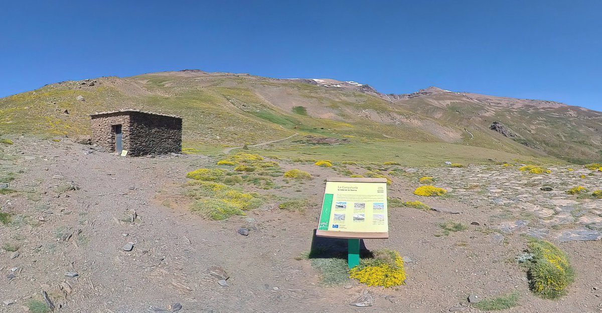
The route of the Virtual Tour starts outside Hotel La Fragua I, where I stayed in Travélez the night before the grand expedition. It follows a well-marked trail, the PR-A-27 “Sendero Travélez – Siete Lagunas” which as its name suggest and the information board at the trail head tells you, takes you from Travélez at around 1400m to the Siete Lagunas (Seven Lakes), one of the most beautiful high mountain landscapes in all of the Sierra Nevada. After following the first section of the trail on the Piedra Roja path to Piedra Redonda, a steep ascent takes one to the Acequia Gorda which is followed and crossed before reaching the area known as Campiñuela at around 2400m and the modest emergency Refugio vivac La Campiñuela.

Refugio vivac La Campiñuela, Sierra Nevada, Spain.

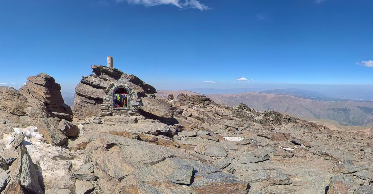
From Refugio vivac La Campiñuela it was a pleasant walk to the Culo Perro river where the regular fording point of the PR-A-27 was made impossible by waters running deep with the melting snow still lingering in patches high above. After locating an alternative crossing point, and climbing alongside the waterfall of the Chorreras Negras (Black Rocks), I finally arrived at the Siete Lagunas, or rather the lower and largeest of the seven lakes, Laguna Hondera. This was unlike any of the photos I had seen, overflowing with melt water and filling the valley as a broad river rather than the timid lagoon often pictured. I found a large flattish boulder and basked in the sun, ate lunch and observed if I would have time to detour to La Alcazaba (The Castle), a 3369m peak off to the north and of significant repute. Alas I did not. The route of a direct ascent from La Alcazaba to Mulhacén is unclear and described as a challenging scramble. Thus it was potentially unsuitable for someone burdened with a 14Kg backpack, and I would be retracing my steps to my boulder. No, it would make more sense to push on to my primary target, Mulhacén I. On route I would take in Mulhacén II, at 3362m included in lists of the ‘Los Tres Miles’, though for what reason I could not say, there appeared to be no significant elevation, and many more rocky outcrops that did. However it was and is clearly marked by a concrete triangulation pillar and no great hardship to reach. And indeed from Mulhacén II it is an easy path up to the nation’s high point and its cluster of ruins, shrine, cairn, and triangulation pillar.

The summit of Mulhacén, Sierra Nevada, highest mountain in European Spain.

I spent some time at the summit, appreciating the views that had been obscured by cloud on my previous visit, and chatting to a friendly young man originally from Palestine but now living in Hungary. Then for the rapid descent to the Refugio at Laguna de la Caldera where I tried and failed to muster the motivation to climb the one hundred and sixty metres to Puntal de la Caldera (3222m). Instead I spent the evening preparing dinner and conversing with Federico, a Spanish hiker of similar years as myself.

The Saharan sand that had turned Spain’s sky an otherworldly orange a few months earlier, blotting out the sun, and coating every surface in a grimy clay was a reoccurring theme of our conversations. The Spanish have a special name for the phenomenon, they call it the “calima”. Federico liked to add a rather Anglo-Saxon prefix when he spoke about it and for very good reason. Even up here we had not escaped its effects. Nearly every rock was covered, and more importantly the sand had settled into our water supply, the Laguna de la Caldera. Drinking the orange water was the only option if we were to stay hydrated.

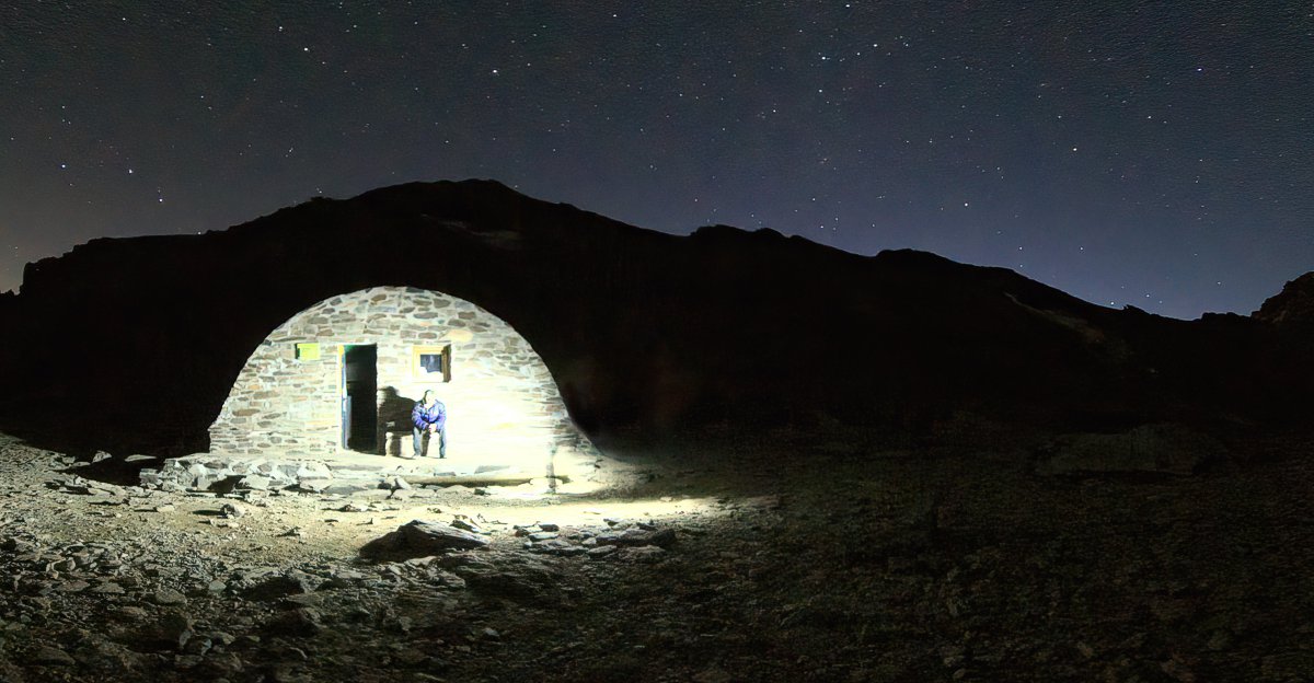
We spoke about wildlife and photography too. Venturing from the refugio at 3:30 am to take panoramas of the night sky, playing with exposures to capture the stars without motion trails, a feel for the mountains, and the hut itself. 20 seconds at ISO400 seemed to provide the best result before the cold and battery failure drove us back inside to the sleeping bags.

Refugio Vivac de la Caldera, Sierra Nevada, Spain.

Refugio Vivac de la Caldera is an unguarded stone built bothy, clean, tidy, and furnished with two sleeping platforms, one above the other, sufficient for fourteen. There is also a wooden topped stone table and pair of benches for meals. And it was on this that I made hot chocolate for breakfast as the sun rose on day two. Expand article

The summit of Mulhacén, Sierra Nevada, highest mountain in European Spain.

List of Los Tres Miles:


The list of peaks that qualify for Los Tres Miles (The Three Thousand) is disputed. It does not help that different sources provide different heights for the same summits. A named 3000 metre summit maybe absent from this list due to insufficient prominence in height between itself and neighbours.

PeakSort

HeightSort

RankSort

Mulhacén3479m01
Valeta (Not in tour)3396 m02
La Alcazaba (Not in tour)3369 m03
Mulhacén II3361 m04
Cerro de los Machos (Not in tour)3329 m05
Puntal de la Cornisa (Not in tour)3316 m06
Peñon del Globo (Not in tour)3279 m07
Puntal de Siete Lagunas (Not in tour)3244 m08
Tajos de la Virgen (Not in tour)3228 m09
Puntal de Loma Púa (Not in tour)3224 m10
Puntal de la Caldera (Not in tour)3223 m11
Pico de Loma Pelada (Not in tour)3183 m12
Cerro Pelao (Not in tour)3181 m13
Puntal de Laguna Larga (Not in tour)3178 m14
Puntal de los Cuartos (Not in tour)3158 m15
Tozal del Cartujo (Not in tour)3152 m16
Pico del Cuervo (Not in tour)3144 m17
Raspones de Rio Seco (Not in tour)3142 m18
Puntal de Juntillas (Not in tour)3139 m19
Puntal de Vacares (Not in tour)3136 m20
Atalaya (Not in tour)3135 m21
Tajos Negros Cobatillas (Not in tour)3116 m22
Cerro del Mojon Alto (Not in tour)3107 m23
Picon de Jerez (Not in tour)3090 m24
Veta Grande (Not in tour)3085 m25
Pico del Tajo de los Machos (Not in tour)3085 m26
Puntal de El Goteron (Not in tour)3067 m27
Puntal de las Calderetas (Not in tour)3066 m28
Cerrillo Redondo (Not in tour)3055 m29
Juego de Bolos (Not in tour)3019 m30
Cerro del Caballo (Not in tour)3011 m31